Saturday, August 27, 2011

Back to life: The Stadtschloss

Nowadays, when people walk along Schloßplatz, they'll certainly notice the empty esplanade between the Dom and the baroque New Stable, between the Lustgarten and the former seat of the Staatsrat, the executive organ of the DDR government. An empty spot in the very centre of the Spreeinsel, and therefore in the very heart of the city. Until recent years, the place was dominated by the so-called Palast of the Republic dating from GDR times. Long before, another structure was built in the same spot, first a small castle. The building would later turn into a ducal residence and finally, into the palace until 1950 stood on the Schloßplatz. Today, in conmemoration of 950 years of the House of Hohenzollern, I've brought back to life the former seat of the Prussian government, this iconic residence that was lost in the 20th century and that is going to be at least partly rebuilt.

{{KMZ file for download will be avaliable soon}}

View of the Kaiser-Wilhelm-Brücke and Stadtschloss in the late 19th century

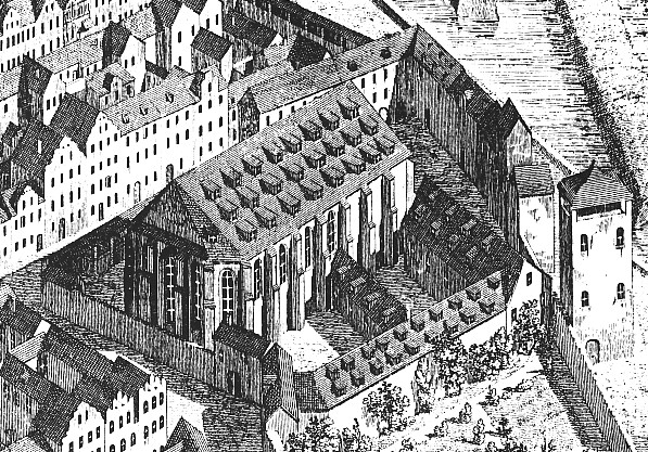
Not unlike the similarly fated Königsberg Castle, the Berliner Schloss originated from a defensive structure that, in this case, guarded what is now the Rathausbrücke. Around 1443, this simple fortification was converted into a castle by elector Frederick II of Brandenburg. A small chapel, the Erasmuskapelle, was added two decades later, and in the following century, the fort was made a permanent Hohenzollern residence. Around the same time, the Renaissance transverse wing (that contained the Alabastersaal), Duchess Elisabeth's House and the court pharmacy (the Schlossapotheke) were built.

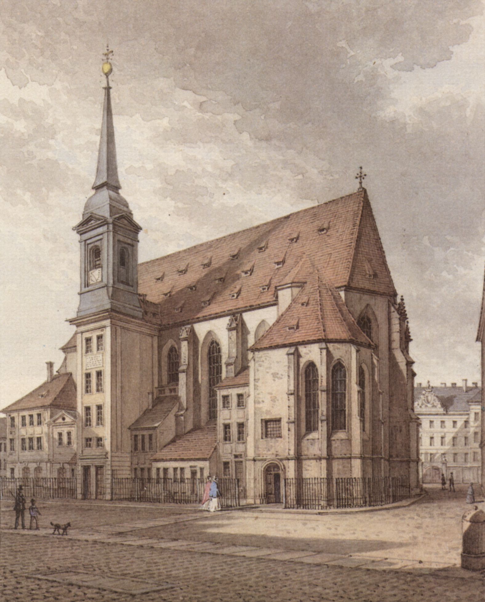
Spree façade in 1880, note from left to right, the Duchess' House, the Kurfürstengalerie and the Schlossapotheke

Frederick William I, known as the Great Elector, renovated the palace after the devastation caused by the Thirty Years' War. Under his rule, the Kurfürstengalierie (that connected the Duchess' House and the Apotheke) and the Braunschweig Hall were built. A memorial to honour the Elector was placed on the nearby Lange Brücke in 1698.

View of the monument to Friedrich Wilhelm I of Brandenburg and the Spree-façade, towards north. Dom by 2nd Clemens)

The Stadtschloss saw many changes in the 1700s, this mainly because of the appointment of Andreas Schlüter (who also designed some parts of the nearby Zeughaus) as Chief Architect a year earlier. Under Schlüter, the western, southern und northern wings, that until that time were little more than simple corridors connecting the structure at the Spree to the transverse wing and the Münzturm, were converted into a splendid Baroque residence. After Schlüter was dismissed in 1706, Architect Johann Eosander von Göthe finished the southern and western wings, adding Portal II to the former, and the great entrance, Portal III to the latter. Eosander's project also included the demolition of the transverse wing and the construction of a 100 m. tower, although neither of those ever took place. Courtyard I was finished around the same time.

The Schloßhof I by Eosander von Göthe, around 1830. Painting by Eduard Gaertner

Although there were many modifications regarding the interior, few changes were made to the external walls. One of these were the construction of the dome by Friedrich August Stüler in 1845, following plans of Karl Friedrich Schinkel, and the addition of two horse sculptures (the Rossebändiger by Peter Clodt von Jürgensburg), given by Nicholas I of Russia, in 1858. Minor modifications were made to the walls of the transverse wing that faced Courtyard II. The pharmacy wing was also modified.

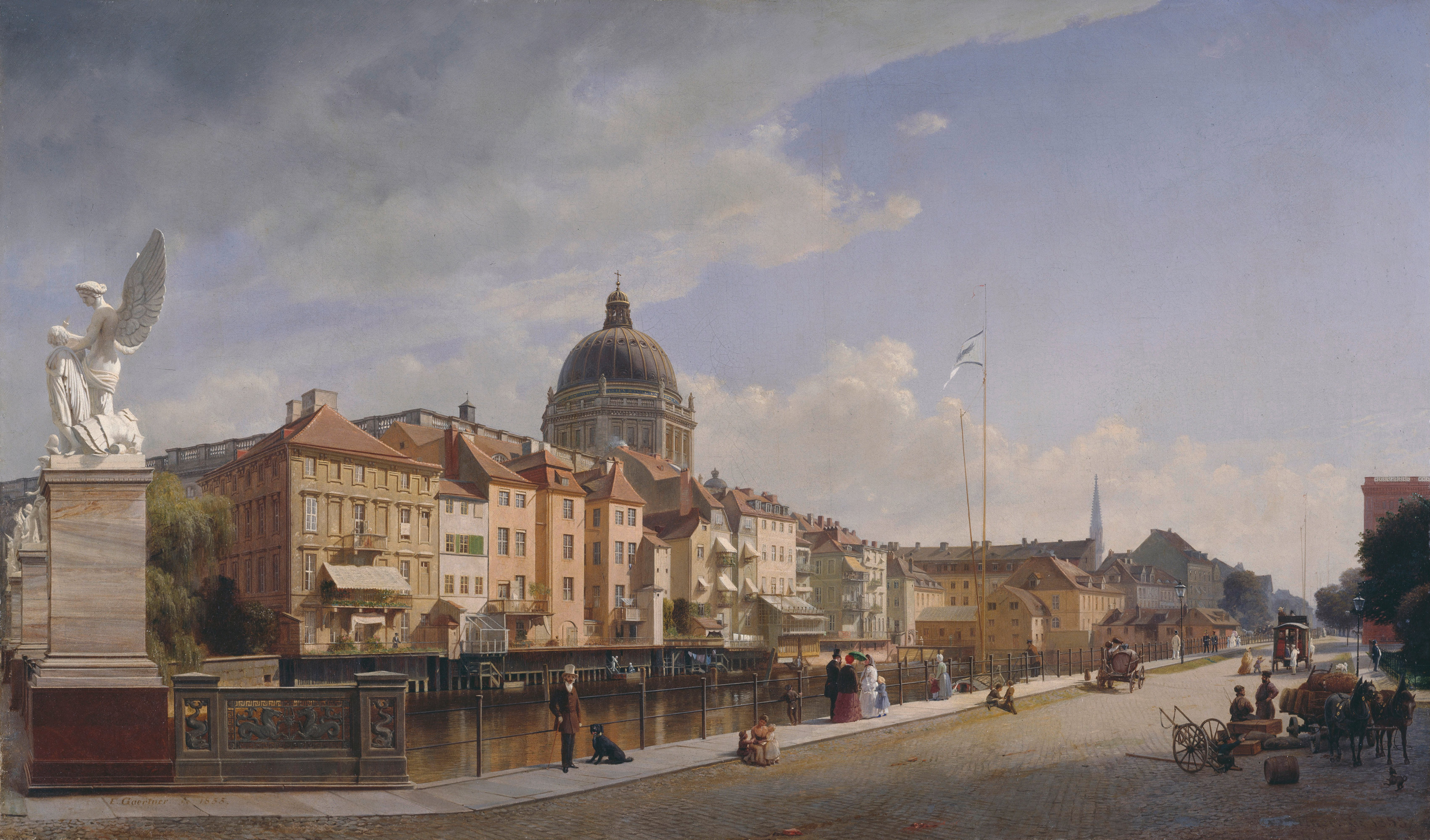
Stadtschloss and Schlossfreiheit in 1855. Painting by Eduard Gaertner

A major change to the arounds of the palace was the construction of the Kaiser Wilhelm National Memorial across the street from Portal III between 1888-89, on the place of a residential complex known as the Schlossfreiheit, that included parts dating back from the 17th century. The focal piece of the monument was an equestrian statue of Emperor William I above a pedestal with four lions, a classical colonnade around it.

Kaiser Wilhelm National Memorial

In the midst of the German Revolution, Communist leader Karl Liebknecht proclaimed a socialist republic, that proved to be short-lived, from Portal IV in November 9, 1918. As the new government core was now at the Wilhelmstraße, the building didn't played a big role in the Weimar Republic politics, but did housed one of the largest art collections in the city.

Stadtschloss in the current Berlin cityscape (Fernsehturm by Frank, Staatsratsgebäude by AcidGraz)

View from the curious "round corner" towards Nikolaiviertel

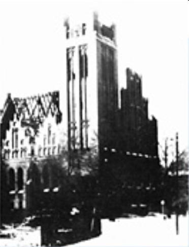
And...well, the rest is known history. The Stadtschloss got bombed two times, the second one by incendiary bombs. Still the building was fit enough to be rebuilt, as you can see here, the damage was not as severe as in other buildings in the city (the Ordenspalais, for example) and could have been repaired. The SED, however, decided to blow up the still impressive palace along with the Nationaldenkmal in 1950, under the typical 'Prussian imperialism' pretext that was used with the Potsdamer Stadtschloss and the Königsberg Castle.

The square stood empty until 1973, when construction of the Palast der Republik started. The asbestos-full structure was dismantled in stages, finishing in 2008. Part of the Stadtschloss is being rebuilt, but well...that's another story. Until then....Enjoy!

Sunday, June 26, 2011

Dresden again (I)

In the last two weeks you might have noticed three more models of mine, this time in the Saxon capital city of Dresden. Since last April the Zwinger palace has been avaliable in Google Earth, and now more models are ready to be shown close to it.

Let's start with the Sophienkirche.

The story of this church started in the year 1272, when the Franciscans built a monastery (Franziskanerkloster) in the arounds of the city walls and what was to become the Dresden Castle. In the first half of the 14th century, the first structure was demolished, and a new, larger one was built, with the distinctive two choir areas.

Klosterkiche and monastery around 1550

Around 1541, in the time of the Reformation, the monastery was abolished and the Franciscans left the place. The building stood empty until it was reopened as a Lutheran church by Sophie of Brandenburg in 1610. In the following century, the Sophienkirche also became the city's Evangelical court church
(Evangelische Hofkirche). Another change around the same time was the installation of a Silbermann pipe organ between 1718 and 1720, in which Bach probably performed (It shoud be noted that his son Wilhelm Friedemann was organist in the church from 1733).

Source: bildindex.de

Starting from 1864, the church configuration was modified - the baroque side tower was replaced by two neogothic spires and aisles were also added, although the Gothic nave from 1331 and the Busmannkapelle from the early 15th century remained with only minor modifications. The last prewar change were the copper-covered spires that from 1932-3 replaced the neogothic ones, which by that time were neglected because of the weather.

Before 1864

Around 1890

After 1933

Although the church, like most of Dresden, was gutted by fire as a consequence of the devastating air raids of 13-15 February 1945, the main structure remained in a relative good condition (see this photo from 1960). Some elements, like the Nosseni and Sacristy Altars were salvaged, before the ruins of the oldest church in Dresden were blown up in 1962 under SED decree. The party chief Walter Ulbricht had commented before, "A Socialist city does not need Gothic churches!".

Starting from 2009, a memorial has been under construction. Resembling the Busmannkapelle, it's scheduled to be finished this year, although no project for the church as a whole has been planned yet.


Other buildings like the Altstädtische Hauptwache were spared from total destruction. This structure was built by Joseph Thürmer following plans by Schinkel in 1830-32 as a guardhouse for the Royal Castle, located just across the street. After WW2, the city government decided to keep and restore the outer walls, although a new, modernist interior was built.


Last in this post, but not less important, is the Monument to King John of Saxony. Located in the center of the Theaterplatz, this memorial consists in a equestrian statue cast by Johannes Schilling in 1889.

Sunday, April 17, 2011

Let's see...

I have been unable to post here in those last weeks because, well, I have been making more models I hope to upload in this week. I apologize for that.

Today, a friend of mine and renowned 3D modeler told me that someone had copied and reuploaded one of my models as if it was his work. More precisely, I'm talking about the model of Hallesches Tor.

I've checked it, and I saw it was, in fact, a copy of my work, not what is considered to be derivative work i.e. a improved version of the original model. Maybe it has the original description with the original copyright disclaimer in it, but that's just a sign saying that this guy just didn't care about giving the appropiate credits to the model owner (i.e. me), and reposted the description only to fill the space.

Minutes later, I found out that this same guy, whose name is (I guess) Supakrit Ngamdeevilaisak, had uploaded two more models made by me, the U-Bhf. Nollendorfplatz and the Friedenssäule in the Mehringplatz. I have already reported the Hallesches Tor copy. I don't want to do this, but by now and as a protective measure, I feel forced to restrict downloads of all my models.

So..

Supakrit,

Take this only as a friendly request to remove your copies of models made by me. I hope you will do the right thing. Otherwise, I will have to report you again.

Saturday, February 19, 2011

The "Historical 3D layer",revisited

Some time ago, blogger and 3D modeller Zoungy wrote a post about the possibility of having a "Historical 3D layer" in Google Earth, i.e. a separate layer including terrain and models of buildings from 50, 100, or even 200 years ago. In Germany, this would mean, for example, 1920s Berlin, or Potsdam before the the bombings. Just think how great cities like Frankfurt am Main or Nuremberg would look with their old buildings rebuilt in 3D.

In Berlin, for example, we would be able to see the old Potsdamer Platz, with its hotels and restaurants, or an impressive view of the Unter den Linden boulevard towards the Stadtschloss. A picture including the old excise wall (Gr. Aksizemauer) with its 18 gates. Maybe, even a reconstruction of the Berlin Fortess could also be possible.

In Google Earth, some German cities have historical imagery dating back from 1943, before being bombed. Big cities like Frankfurt am Main, Dresden, Köln, Lübeck, Nuremberg, Berlin, Stuttgart, Hamburg, Frankfurt an der Oder, Magdeburg, Leipzig, Göttingen, Koblenz, Freiburg, Hannover and Kiel are an example of this. While this pictures are not in HQ, modelers can use them as a reference for the location of old buildings. Former German cities in this category include Straßburg in the Alsace, Danzig in former West Prussia, and Breslau in Sliesia.

Berlin also has good quality imagery from March 1945, that covers Tiergarten, part of Moabit Potsdamer Platz, part of Mitte (without part of Friedrichstadt and the area around Gendarmenmarkt), , and Tempelhof airport, comprising a total area of 16.5 km2. Also, there is a 1950 archive covering all of Berlin and part of Potsdam.

Basically, there are three main problems regarding the historical imagery. First, the quality of the 1943 archive should be improved to have a clear view of the blocks and streets. Second, the imagery should match with the most recent pictures (usually, old pictures are displaced). Finally, the pictures should be colored to give the feeling of reality. Once those questions have been solved, we will be able to travel back in time and enjoy the beauty of the great German cities.

Monday, February 14, 2011

Berliner Stammstrecke, Busmannkapelle


109 years ago, the first line of the Berlin metro (Untergrundbahn, U-Bahn for short), was inaugurated by Kaiser Wilhelm II. This first line (known as the Stammstrecke), now part of the U1 and U2, ran from Stralauer Tor (in the eastern end of the Oberbaumbrücke) to Zoologischer Garten, and served 12 stations: Stralauer Tor, Schlesisches Tor, Oranienstraße (today Görlitzer Bahnhof), Cotbusser Thor, Prinzenstraße, Hallesches Tor, Möckernbrücke, Gleisdreieck, Bülowstraße, Nollendorfplatz, Wittenbergplatz and finally, Zoologischer Garten, in addition, a short track ran from Gleisdreieck to Posdamer Platz. In the same year, the service was extended eastwards to Warschauer Brücke (today Warschauer Straße), and Knie.

Viaduct under construction: Wassertorplatz, between Prinzenstraße and Cottbuser Thor

Early on this day, I uploaded to the Warehouse two of these stations, which had different fates: Stralauer Tor and Nollendorfplatz.

U-Bahnhof Stralauer Tor, 1902

Stralauer Tor, located in the eastern end of the Oberbaum bridge in Friedrichshain, received its name after the historical city gate of the Berlin customs wall (Akzisemauer), located in the same spot. The station served as the U1 terminus until the completion of Warschauer Brücke, later that year. Stralauer Tor was renamed Osthafen in 1924, and continued to serve using that name until WW2. In March 1945, the elevated station was heavily damaged by Allied bombing. The Communist authorities decided not to rebuild U-Bhf. Osthafen because of its close proximity to the boundary between Sovied and American occupation sectors (i.e. East and West Berlin).

Named after the village of Naklérov in today Czech Republic (site for the 1813 battle of Kulm), U-Bahnhof Nollendorfplatz is located in the square of the same name in Berlin-Schöneberg. It was subject to many modifications - the eastern entrance hall was modified in the interwar years, first in 1923 and later in 1926/27. The structure from 1927 is the only part that remained until our days.


Again, Allied bombing left the station unsuitable for service (the eastern end of the elevated building had collapsed). Damage was partly repaired and by the early 1950s the station was back in service. However, the remains of the old building were demolished, and the current new structure was built. By the same time, the square, lost its old shape. On 1999 a simplified dome was added to the building, but unlike the original dome, it is just an ornament.


Other stations had a different fate. U-Bahnhöfe Oranienstraße and Warschauer Straße are almost in their original condition; U-Bahnhöfe Wittenbergplatz and Schlesisches Tor survived the war intact; U-Bhf. Bülowstraße was enlarged in 1929; the stations Cottbusser Thor and Möckernbrücke were demolished and rebuilt in the 20s and 30s, the former 170m westwards as a two-level station, and the latter had a new structure built because of increased number of passengers; Hallesches Tor and Prinzenstraße survived with postwar modifications.

At the same time, on a totally different context, I uploaded the model of the Busmannkapelle in Dresden. The Sophienkirche, Dresden oldest church, was originally part of the Franciscan monastery (Dresdner Franziskanerkloster), that was demolished around 1330 for the construction of a new, Gothic church.


As we all know, the Busmannkapelle, along with the Sophienkirche and the Dresden city center burned after the devastating air raid carried out by Allied forces in the nights of February 13th and 14th. This is an excerpt from a letter written by American ssoldier Kurt Vonnegut, who had been captured the year before, and was imprisoned in a underground slaughterhouse in Dresden by the time of the attack.
On about February 14th the Americans came over, followed by the RAF, their combined labors killed over 250.000 people in twenty four hours and destroyed all of Dresden - possibly the world's most beautiful city.

The Sophienkirche was gutted by the resulting inferno. However, the structure remained standing and a restoration could have been possible. Sadly, the ceiling and part of the the northern tower collapsed in 1948 as a result of the damage. Its fate was uncertain until 1950, when the SED party chief Walter Ubricht commented that "a socialist city doesn't need gothic church towers", dooming the church. Despite the protests by architects and overall population, the Sophienkirche remains were blown up in 1962.


I hope to make an extended post about the Sophienkirche later. I'm currently making the 3D, but I need more color pictures.

Thursday, February 3, 2011

Schneidemühl II - Main station and demolished church

In the last two weeks I have uploaded some new models to the Warehouse. Almost all of these buildings are located in Schneidemühl, today Piła, in Poland. The first one is the Piła Main Station complex, known as Piła Główna in Polish.

The Hauptbahnhof Schneidemühl complex was built between 1851 until the 1876, when the city was part of the Province Posen in the Kingdom of Prussia. By those years, the complex, which included a train depot 430 m. eastwards, became an important part of the Prussian Eastern Railway that connected Berlin with Königsberg, and in the following years new lines were built connecting Piła with Posen, Neustettin, Flatow, Bromberg, Danzig, Frankfurt on the Oder and Wałcz (Gr. Deutsch Krone).

Picture from schneidemuehl.net.

The station was extended westwards in the 1920s, by those years the building lost its initial ornaments and took its current shape. The building survived WW2 unscathed.


Regarding the train depot from 1874, it fel into disuse in the 1990s. The main part of the depot, i.e. the roundhouse, is waiting for a restoration. You can find more information and pictures in this website (not mine).

The next model is the Johanniskirche, which didn't have enough luck to survive to these days.

Picture from schneidemuehl.net.Note that the house next to it is still standing.

The Protestant Church of St. John (św. Jana in Polish) was built between 1909 and 1911 in a Neogothic style by German architect Friedrich Oskar Hoßfeld as home to a United Prutestant congregation.

Picture from dawna.pila.pl.

As you can see above, the church resulted with moderate damage (the roof and spire burned down), but could have been easily restored. However and as usual, the Communist government decided to blow up the building, as it did so in the 1950s. Three other churches suffered a similar fate.

As happens usually with other buildings that do not exist anymore, the geometry work was the easy part. However, looking for other churches with similar caracteristics and some reference pictures was enough to get such a beautiful result. I hope this model to serve as a basis for a future reconstruction in Piła, one day. Enjoy.


Saturday, January 15, 2011

Schneidemühl

Few days ago, I uploaded the Heiligen-Familie-Kirche, a Catholic church in the now-Polish city of Schneidemühl (Pl. Piła). This church is probably the most important landmark in the city, for it is one of the few buildings that survived the war, and a recognizable structure in the town.


The city of Schneidemühl/Piła (sawmill and saw in German and Polish respectively) was on its early history a settlement of German people coming from the west (mainly Brandenburg and Pomerania). The area become Polish on 1368, and Schneidemühl got its city rights in the early 16th century. The town suffered two fires in the following century, along with an outbreak of the Plague in the mid-18th century.

Schneidemühl became officially part of Prussia (Province of Westpreußen) after the first Partition of Poland in 1772. Nine years later, the town was again devastated by fire. In the Napoleonic Wars, Schneidemühl was ceded to the Duchy of Warsaw after the Prussian defeat at Jena. However, the city was granted to Prussia in the Congress of Vienna in 1815. This time, the town belonged to the Grand Duchy of Posen, territory ruled by the King of Prussia in personal union. During this period, the city experienced a big development process. However, the town suffered another fire in 1834. Ironically, Schneidemühl was revisited by another catastrophe, this time a flooding, in the late 19th century.

But the worst was to come. In the final stages of WW2, Adolf Hitler declared Schneidemühl a Festung. The city was assaulted by a joint Polish-Soviet army, and after the attack, over 80% of the city was in ruins. The communist government didn't care about the buildings that could be salvaged. Schneidemühl was then converted into the model Communist city, an architectural mess full of Plattenbäuten, where a true jewel on the Küddow river once stood.

There are few remarkable buildings that survived the war.
  • The Heligen-Familie-Kirche, originally a wooden church from the late-14th century, was rebuilt in brick in 1726, and again in its current neo-baroque form in 1910-12.
  • The Moltkeschule.
  • The Hauptbahnhof, built between 1853-76, extended in the 1920s.
  • The Regierungsgebäude and Reichsbank building, both on Danziger Platz.
  • The Stanislauskirche in Bromberger Vorstadt.
  • The Postamt, which has retained part of its prewar facade.
Notable structures that were lost in the war include:
  • The Rathaus (city hall) on the Neuer Markt
  • The Evangelische Stadtkirche on the Neuer Markt.
  • The Polnisches Kirche (also known as the Alte Katholische Kirche), the oldest church in the city. First a wooden church from the 14th century, it was rebuilt in 1619-28 and 1742, when it got its final shape. The church burnt out in 1945 and its remains were demolished in the 1970s.
My plan is to rebuild some of these buildings in 3D. By now, you can see pictures and information about Schneidemühl/Piła in these two interesting websites (not mine): schneidemuehl.net (German) and dawna.pila.pl (Polish), by the same author. While its kind of difficult to find pictures of this city, I hope to upload more Piła-related models soon. See you!

Saturday, January 1, 2011

Still in Potsdam - Happy New Year!

In the last week I uploaded three new models to the Warehouse, all of them located in the Brandenburg capital, Potsdam.

The first two are not so far from my Stadtschloss - since they three are on the same square. The Alter Markt is the location of both the Marble Obelisk and the Church of St. Nicholas.


Uploaded on December 25, the Marmorobelisk was my small gift for Christmas. The monument was erected in 1753 by order of Frederick II, by then King in Prussia. It's on the middle of the Old Market, facing both the City Palace to the south and the Nikolaikirche to the north. Construction of the latter began in the 1830s under direction of Karl Friedrich Schinkel, who would not live to see his last work finished. After his death in 1941, his students Ludwig Persius and Friedrich August Stüler oversaw the completion of the neoclassical church, and the dome that was planned by Schinkel.


Regarding the Belvedere auf dem Klausberg, its construction was commissioned by Frederick II to Architect Georg Christian Unger (who built also the Royal Library in Berlin), and was finished in 1772. King Frederick William IV had the Belvedere as an important part of his planned Triumph Avenue that, however, was never realized. The building was to be the end of the Avenue that would have run from the Triumphtor.


The attack carried out by RAF on April 14, 1945 left the Nikolaikirche heavily damaged and the Obelisk with minor scars. The Belvedere, that escaped bombing, was shelled by the Allies by the same time and reduced to rubble, being the staircase the only recognisable remains.

Restoration of the Nikolaikirche and Marmorobelisk begun in the early 1950s, while the Belvedere had to wait until 1990, when the Stiftung Messerschmitt financed the reconstruction. When finished, it was transferred to the Prussian Palaces Foundation Berlin-Brandenburg.